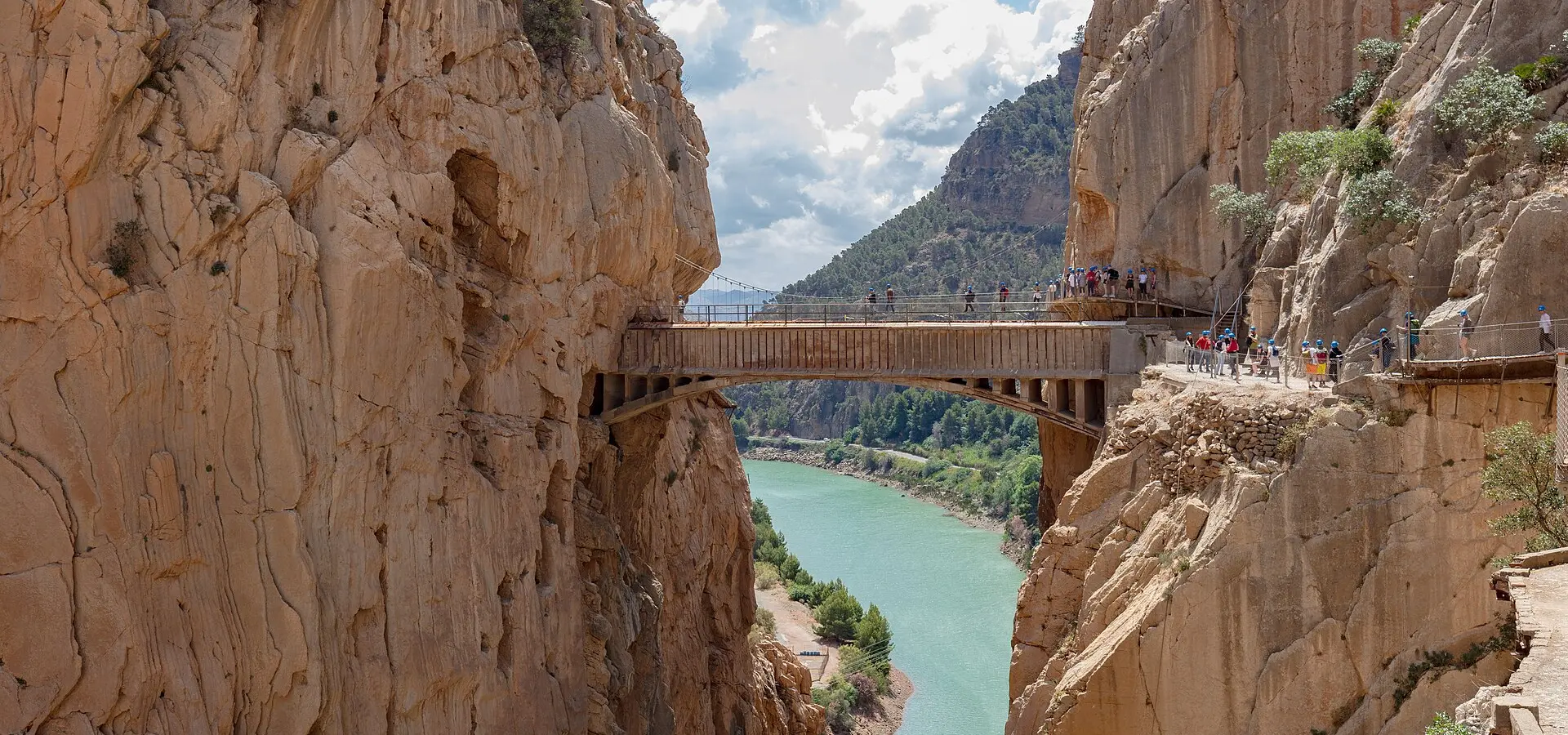
Caminito del Rey, El Chorro and Antequera
Best Season
Mediterranean: accessible all year. Hot in summer. Occasional rain in autumn-winter.
The Gaitanes Gorge and the famous Caminito del Rey walkway, El Chorro reservoir gorges, and Antequera with its UNESCO dolmens. Spectacular inland Málaga.
Highlights
- 1Caminito del Rey: a walkway above the gorge
- 2Desfiladero de los Gaitanes: a 700 m canyon
- 3The Antequera dolmens (UNESCO)
- 4El Torcal: a surreal karst landscape
About this route
The Desfiladero de los Gaitanes is one of the most spectacular gorges in all of Spain: a limestone chasm 700 metres deep and barely 10 metres wide at its narrowest, cut by the river Guadalhorce in the heart of the Málaga sierra. The Caminito del Rey, the walkway threading through the gorge 100 metres up, was for decades "the most dangerous path in the world" — abandoned and falling apart — and has become, since its 2015 rebuild, one of the most visited attractions in Andalusia.
The MA-5403 skirting the El Chorro reservoir and passing alongside the Desfiladero de los Gaitanes is a little-known gem for riders: it runs between vertical limestone walls, ducks through tunnels cut into the rock, follows the turquoise water of the reservoir and offers views down into the gorge that are genuinely vertiginous. El Chorro is also one of Spain's foremost climbing destinations, its limestone walls drawing climbers from around the world.
Antequera, 45 km north of Málaga, is a monumental town holding an artistic heritage out of all proportion to its size: more than 30 churches and convents, a Moorish alcazaba overlooking the Peña de los Enamorados (a mountain profiled like a human face, which the Romantics tied to a legend of love between a Christian and a Moorish woman), and above all the dolmens of Menga, Viera and El Romeral, declared a UNESCO World Heritage Site in 2016. The Dolmen de Menga, dated to around 3700 BC, is the largest passage dolmen in Europe.
El Torcal de Antequera, just outside town, is a surreal karst landscape: a maze of limestone formations eroded by water and wind over millions of years into impossible shapes — columns, mushrooms, arches, towers — that look like a science-fiction set. The road up to the Torcal visitor centre (A-7075) is short but lovely, curving between the rocks with views over the whole Antequera plain.
Practical notes: the route is rideable year-round in a Mediterranean climate. The Caminito del Rey must be booked online in advance and sells out weeks ahead. Fuel is easy to find in Antequera and Álora. For a bed, Antequera's Parador — in a 16th-century convent — has a pool and views of El Torcal. For food, porra antequerana (a cold tomato cream, thicker than salmorejo, a local speciality) and molletes de Antequera (soft rolls with olive oil and ham) are essential.
Route stops
Caminito del Rey
Viewpoint
Walkway 100 m above the Gaitanes Gorge.
Embalse de El Chorro
Viewpoint
Turquoise reservoir between limestone walls.
El Torcal de Antequera
Viewpoint
Surreal karst landscape with limestone formations.
Dólmenes de Antequera
Monument
UNESCO dolmens (3700 BC), Europe's largest.
Practical information
Weather
Mediterranean: accessible all year. Hot in summer. Occasional rain in autumn-winter.
Traffic
Moderate traffic. Caminito del Rey very popular (book online).
Fuel stops
Petrol stations in Antequera, Álora and Ardales.
Where to stay on this route
The towns this route passes through — useful for splitting it into stages or sleeping near the start. Book ahead in high season.
- Dólmenes de AntequeraSee places to stay
- AntequeraSee places to stay
Affiliate links: if you book through them, Nomadiq earns a small commission at no extra cost to you.
Related routes
Axarquía: Comares, Frigiliana and Málaga's Mudéjar Route
Andalusia
Córdoba's Subbética: Zuheros and Priego
Andalusia
Ronda and the White Villages
Andalusia
Costa Tropical: La Herradura and La Contraviesa
Andalusia